Hong Kong Observatory Monitors Low Pressure System, May Issue Standby Signal
HK01 · 2 SOURCESabout 2 hours ago3 MIN
Summary
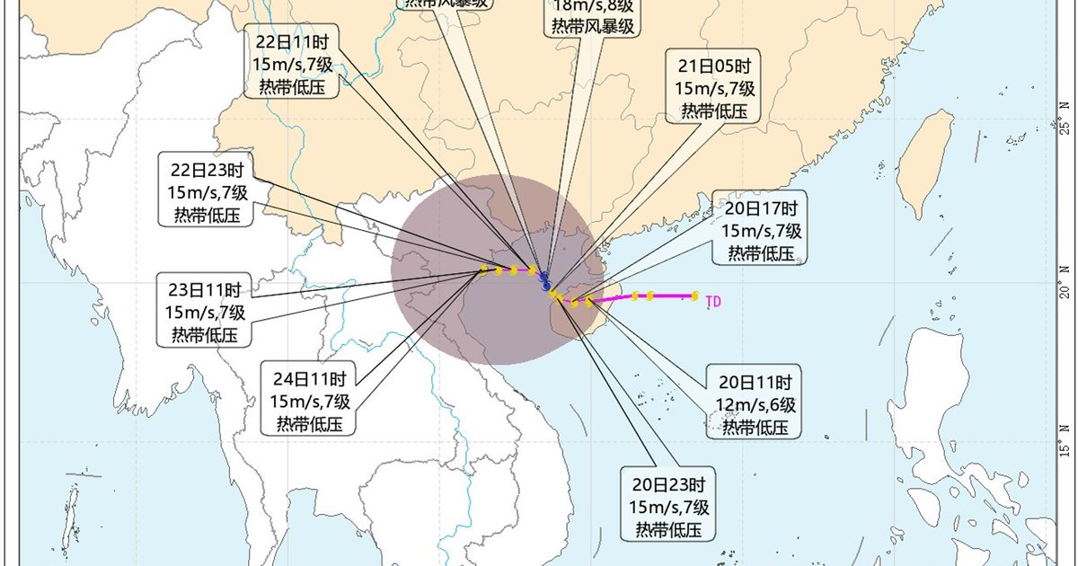
The Hong Kong Observatory announced on Wednesday that it is closely monitoring a low pressure system currently situated in the northern South China Sea, which is gradually moving toward Hainan Island. According to the Observatory, the system remains relatively loosely structured and has not yet intensified into a tropical cyclone . The low pressure area is expected to cross Hainan Island on Thursday and move away from Hong Kong, though officials warn that significant uncertainty remains regarding its subsequent path . The system could potentially shift northward toward the Beibu Gulf and Leizhou Peninsula area, or alternatively turn eastward to approach the Guangdong coastline . The Observatory has stated it will continue to assess whether conditions warrant issuing a No. 1 Standby Signal.
Key Points
- The low pressure system made landfall near Longlou Town, Wenchang City, Hainan Province at approximately 5:40 a.m., with maximum sustained winds of 6 on the Beaufort scale (12 metres per second) and a central pressure of 997 hPa .
- By 8:00 a.m., the system's center was located over Chengmai City in Hainan, with outer winds reaching 7 Beaufort (15 metres per second) and a minimum pressure of 998 hPa .
- The China Meteorological Administration forecasts the tropical depression will strengthen into a tropical storm as it moves into the Beibu Gulf at 10 to 15 kilometres per hour before becoming stationary and intensifying .
- A second low pressure area east of Taiwan is expected to linger over the southern East China Sea for the next one to two days, while Tropical Storm Saudel is tracking toward waters east of the Ryukyu Islands with no anticipated impact on Chinese waters in the next five days .
- Hong Kong residents can expect unsettled weather through the weekend with southerly winds of 3 to 4 on the Beaufort scale, periods of cloudiness, scattered showers, and thunderstorms, with heavier rainfall in some areas initially .
Why It Matters
The development of this low pressure system has significant implications for public safety and emergency preparedness in Hong Kong. Should the system reverse course and approach the Guangdong coast as forecast, it could bring severe weather conditions including strong winds and heavy rainfall to the territory, potentially requiring the issuance of tropical cyclone warning signals that would affect transportation, outdoor activities, and business operations. The uncertainty in the system's trajectory underscores the importance of continued vigilance and public awareness during the remaining weeks of the typhoon season.
The development of this low pressure system has significant implications for public safety and emergency preparedness in Hong Kong. Should the system reverse course and approach the Guangdong coast as forecast, it could bring severe weather conditions including strong winds and heavy rainfall to the territory, potentially requiring the issuance of tropical cyclone warning signals that would affect transportation, outdoor activities, and business operations. The uncertainty in the system's trajectory underscores the importance of continued vigilance and public awareness during the remaining weeks of the typhoon season.