Typhoon Zitan to Make Landfall in Guangdong-Guangxi Region Tonight; Qiongzhou Strait Suspends Operations
Bastillepost · 3 SOURCES41 minutes ago3 MIN
Summary
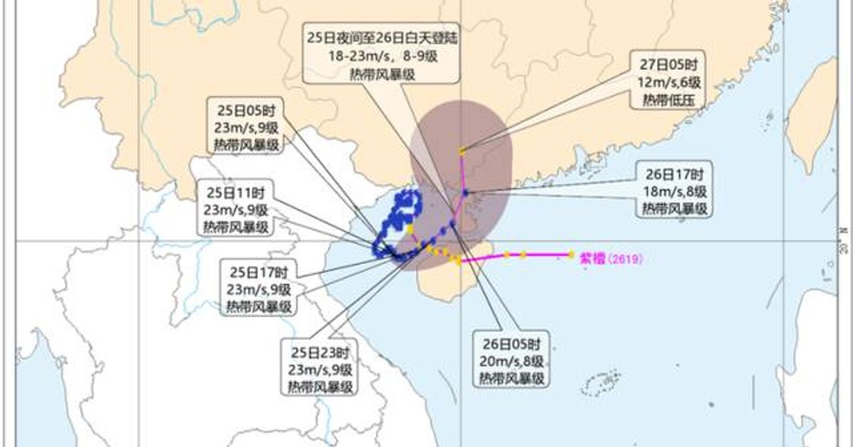
The China Meteorological Administration (CMA) continues to maintain a yellow typhoon warning as Tropical Storm Zitan approaches the southern Chinese coast . The storm, currently hovering over the Beibu Gulf, is expected to make landfall between southeastern Guangxi and the western coast of Guangdong's Leizhou Peninsula tonight through tomorrow afternoon . A rare twin-typhoon situation has developed as Severe Typhoon Saudell, which has weakened from super typhoon intensity, moves toward the Zhejiang-Fujian coastal region . Transportation disruptions are widespread, with the Qiongzhou Strait suspending all ferry services since 9 a.m. today and Hainan's railway operator halting all passenger train services .
Key Points
- Zitan's centre was located at 5 a.m. today approximately 250 kilometres south-southwest of Beihai, Guangxi, with maximum sustained winds of 81 km/h (level 9) .
- The storm is moving northeastward at 9-18 km/h and is expected to make landfall tonight through tomorrow afternoon, maintaining tropical storm intensity .
- Saudell's centre was positioned about 1,020 kilometres east-northeast of Taipei at 5 a.m., with winds of 233 km/h (level 15) and a central pressure of 945 hPa .
- The Qiongzhou Strait suspended all ferry services at 9 a.m. today, with Haikou's three ports (Xinhai Port, Xiuying Port, and Railway South Port) also halting operations .
- All inbound and outbound passenger trains serving Hainan were suspended for the full day today, with partial suspensions scheduled for Wednesday and Thursday .
- Heavy rainfall of 250-400 millimetres is forecast for Fujian, Jiangxi, Guangdong, Hainan, and parts of Taiwan through tomorrow .
- Wind warnings extend across the Beibu Gulf, the South China Sea, the Bashi Channel, the Taiwan Strait, and eastern Guangxi and Guangdong coasts, with gusts reaching level 9-11 .
- Typhoon No. 21 Atsani has weakened significantly and the CMA has ceased monitoring the system .
Why It Matters
The simultaneous approach of two typhoons to mainland China's eastern and southern coastlines represents an uncommon meteorological event that will test the region's emergency response capabilities . Hong Kong, situated between the two storm tracks, may experience indirect effects including enhanced rainfall and rough seas over the coming days, warranting close monitoring of weather bulletins from the Hong Kong Observatory .
The simultaneous approach of two typhoons to mainland China's eastern and southern coastlines represents an uncommon meteorological event that will test the region's emergency response capabilities . Hong Kong, situated between the two storm tracks, may experience indirect effects including enhanced rainfall and rough seas over the coming days, warranting close monitoring of weather bulletins from the Hong Kong Observatory .